

Remember When Hurricane Ike Roared Through Western Kentucky?
Two decades ago, if I'd been asked to list things I don't think would ever happen in Daviess County, I would have eventually gotten to hurricanes. Yes, it's a wild and woolly roller coaster ride when it comes to Ohio Valley weather, but hurricanes? I doubt I would've been alone in my belief. Then, lo and behold, two years later, I would've been proven wrong.
The Morning Hurricane Ike Reached Kentucky
On the morning of September 14th, 2008, I woke up because my apartment had suddenly gotten hot. That happens when the electricity goes out. And the electricity goes out when the remnants of a hurricane rip through your town, packing wind gusts of more than 70 mph and doing a number on power lines.
Moments after I got up, my sister called, frantically wondering what was happening. I told her it looked like a hurricane, not really believing that's what it was, clear up here in Kentucky. But, sure enough, Hurricane Ike, which had slammed into the Texas Gulf Coast the day before, was responsible. Although Ike was no longer technically a hurricane by the time it reached our part of the country, its remnants were racing northeast and producing extraordinary winds across the Ohio Valley.
Gathering the pertinent info at the time played second fiddle to making sure my mother was alright, and she was. But that trip over to her place was quite a thrill ride; there was debris flying everywhere, and a squirrel even hit the corner of my windshield. Considering what Owensboro's Jim Meier captured on camera that day, I guess I'm lucky I made it over there without running into something much bigger.
Hurricane Ike's Remnants Hit Western Kentucky
Ike had made landfall near Galveston, Texas, the previous morning as a Category 2 hurricane with maximum sustained winds of 110 mph. It weakened rapidly as it moved inland, but its remnants raced northeast toward the Ohio Valley, bringing remarkably powerful winds along for the ride.
According to the National Weather Service in Paducah, wind gusts generally ranged from 50 to 75 mph across the region that morning. In Owensboro, a weather station at the Daviess County Courthouse recorded a gust of 73 mph.
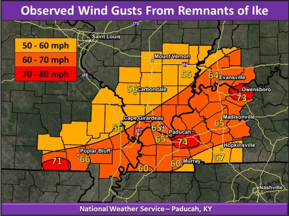
Those winds did exactly what you'd expect. The National Weather Service received reports of widespread damage throughout Owensboro and Daviess County, including numerous trees blocking streets, downed power lines, inoperable traffic lights, and even traffic signals ripped from their lines.
The National Weather Service says Ike's remnants merged with a frontal boundary across the lower Ohio Valley. Abundant sunshine helped create deep mixing in the atmosphere, allowing powerful winds from above to make their way down to the surface. Pop those ingredients in the oven, and, voila, winds of more than 70 mph in Kentucky.
A Hurricane Belongs on Kentucky's Weird Weather List
Here in Daviess County and vicinity, we kid about Ohio Valley weather a lot. You know the old saying, "If you don't like the weather around here, wait five minutes."
We've experienced tornadoes, monster snowstorms, baseball-sized hail, light snow on Derby Day, and actual temperatures in the negative double digits.
And a hurricane. In Western Kentucky.
Why not?
25 costliest hurricanes of all time
More From WBKR-FM