Dave Spencer Relives a Memorable Vacation Out West
When I get the chance, I try to plan my vacations around a very special goal I created for myself many years ago. That goal is to visit every state in the union. I made this decision after visiting California with my family as a teen. At the time, California seemed to be a mythical place where few people like me ever got to go. Hey, I was 14. So I thought, “If I can go to California, why not everywhere else?” And this year, I got to add a few more slices of “everywhere else” to my very own American pie.
Day One: FLOODS AND BACKROADS AND A WOMAN CALLED CORA
It was a day like any other. (Actually, that’s not true; I was leaving town and going on vacation. But I’ve always wanted to say that.) The first few hundred miles or so were a rather uneventful stretch, which was fine by me. But then, I merged onto Interstate 29 in Kansas City, Missouri and that’s when it started to get interesting. As I headed up the highway toward the Iowa state line, and after I had passed through St. Joseph—a city of nearly 80,000 Missourians—I got to a point where I began seeing lots and lots of water on both sides of the four-lane. I had been checking forecasts for a week prior to leaving on my trip and had seen nothing untoward in any part of the country where I was to travel. So I was surprised to see all this flooding.

Soon, signs began to appear on the side of the road indicating the closure of I-29 at mile marker 110. At this point, I was really in the dark. At that mile marker, I hit the off-ramp and merged onto a two-lane road and stopped at a convenience store/truck stop. There was a woman behind the counter whose name was Cora. Cora wore an eye patch and a tattoo on her upper right arm that said “Dwayne.” She was an incredibly nice lady and, I gathered, a fairly patient one, too. I had stopped around 3:30 in the afternoon and before I even opened my mouth to ask about all the flood waters, she whipped out a map of back road detours she’d been giving to wayfaring strangers all day long. And then she proceeded to tell me the story of how a regional division of the US Army Corps of Engineers had miscalculated a release of water from the Missouri River dam farther north, causing the flooding of several hundred acres of land downstream. In relating the story, Cora never missed a beat; there was no telling how many times she had told it that day. So, I grabbed my map and hit the road. And because of all the little two-lanes I had to then travel AND because several semis were travelling them as well, it took me nearly 3 hours to advance only about 60 more miles. Exhausted, I stopped that night in Missouri Valley, Iowa. And before going to bed I decided to change my plans regarding my trip home later in the week. I would NOT be using Interstate 29. Good riddance.
Day Two: GREAT PLAINS, BAD LANDS, AND A PALACE MADE OF CORN

In northwest Iowa, Interstate 29 had righted the ship and there were to be no more detours. I had brought along a John Grisham audio book to keep me company during long stretches, but the discs were scratched and kept skipping. So I reverted to alternating between news, talk, and music. But then I abandoned them all and just rolled down the windows and enjoyed some unbelievably comfortable Upper Midwestern air. After passing through Sioux City, Iowa, I crossed the state line into South Dakota. This was a very momentous occasion; South Dakota became number 42 on my list of visited U.S. states. (Nebraska was #41—I had driven into Omaha on Day One to see if I could circumvent the I-29 nonsense. No dice.) In Sioux Falls, SD, I finally escaped 29 and merged onto Interstate 90. As soon as I did, I saw a rather intimidating mileage marker informing me that Rapid City—where I had hotel reservations—was 385 miles away! So, South Dakota’s REEEAAALLLLY long. No matter. I love being on the road, and especially when I’m in places I’ve never been. Eventually, I came to a town called Mitchell. Now, Mitchell is actually a part of my family history—just not my personal history. Mitchell is home to the famed Corn Palace—a large Russian-looking establishment made entirely of corn. Back in 1963 and before I was born, my parents and sister vacationed out west and stopped there. Dad took a picture of the Corn Palace which I have seen my entire life. So 48 years later, I stood on the same corner he did and took my own picture. I guess you could call it a completion of the Corn Palace Family Circle. I left Mitchell and got on down the road. There was a rest stop positioned near an overlook of the Missouri River. The view was incredible. From one point at the stop, you could look down and see the Lewis and Clark Memorial Bridge which spans the river. And once I got back on the road and actually crossed the Missouri myself, the geography began to change. The plains began to roll and were more expansive. And as I kept driving, the topography became dryer and rockier. I was lovin’ it. And then I came to one of my first destinations—Badlands National Park.

The Badlands cover nearly a quarter-million acres in southwestern South Dakota and are loaded with rocky spires, buttes, and sharp peaks as far as the eye can see, depending on your location within the park. I had never been and was simply blown away. It’s the most amazing achievement in erosion I have seen since I visited the Grand Canyon. I was so excited to be there, I didn’t even let the many “Beware of Rattlesnakes” signs deter me. Oh, by the way, at the visitors center, a ranger informed me that it was a federal offense to remove plant life, fossilized remains, or petrified wood from the park and that if I saw a rattlesnake, I was not to approach it. I told her, “No problem. I also won’t be pouring drain cleaner onto my eyeball.” But, I neither saw nor heard any rattlesnakes and had an amazing time at one of the most unusual and extraordinary places I have ever visited. I can’t wait to go back.
Day Three: FOUR PRESIDENTS AND A CRAZY HORSE

When you head south out of Rapid City, you ascend. Then you ascend some more. And then you ascend some more. And if you get a chance to look back over your left shoulder, you are likely humbled by how far you have elevated yourself above sea level. Such was the case the day I headed into the Black Hills, where every curve was a hairpin, and every other vehicle was a motorcycle. The legendary Sturgis Bike Rally was happening that week and bikers were everywhere. In fact, it seemed as if they nested in Keystone, a tiny South Dakota town that comes off as a kind of Gatlinburg-lite. Once through Keystone, it was this curve and then that curve and I began to wonder when I would actually encounter the monument. Surely it was possible to see it before I made into the actual national park. And, sure enough, as soon as that thought crossed my mind, I rounded a corner and there it was: Mt. Rushmore. Astounding! It’s something with which I was familiar my entire life, but until I actually saw it, I had no idea how magnificent it really was. Seriously, it took my breath away. Inside Mt. Rushmore National Park, there’s a long walkway lined with columns that are engraved with the names of each state and its year of entrance into the union. After spotting Kentucky, I made it to the end of the walkway and a large amphitheatre where several other tourists gathered to take any number of pictures—just like me.
I stepped down into the top row of seats and just sat and stared. It’s fascinating how hypnotic this monument can be. I was just staring. I knew it wasn’t going to move, but I couldn’t take my eyes off of it. But then I did and decided to walk the half-mile trail that wound around the front of the base of the mountain. There were stopping points along the way with information about each of the four presidents—George Washington, Thomas Jefferson, Theodore Roosevelt, and Abraham Lincoln. And there was also a museum detailing the beginnings of the monument. I saw photos of workers on scaffolds doing the sculpting. Can you imagine putting something like this together? Well Gutzon Borglum not only imagined it, he—along with his son, Lincoln, who completed the project after his father’s death—did it. It’s not only a phenomenal American landmark, but a testament to perseverance and ingenuity.

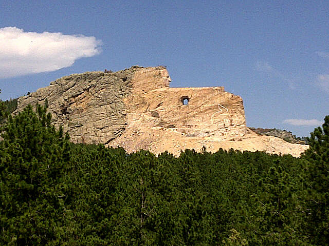
And the four presidents aren’t the only figures from American history enshrined in stone in South Dakota. Travel down the road a bit from Mt. Rushmore and you will come upon the Crazy Horse Memorial. Currently, all you can see is the head of Crazy Horse; work on this monument began in 1948 and is ongoing. The memorial comes with its own museum and fascinating stories about Crazy Horse and other well-known Native Americans from the area. Upon departing the Crazy Horse Memorial, I finished the day by driving into Wyoming—state #43—where I visited the famous Devil’s Tower. Devil’s Tower is a large and imposing monolith in northeastern Wyoming and was the first national monument designated as such—by President Theodore Roosevelt in 1906. It’s cool how you can see Devil’s Tower from just about any vantage point from within a certain amount of square mileage. After the Tower—where I stopped at a campground diner and had a buffalo burger (they’re everywhere out there)—I made my way into Montana—state #44—before returning to Rapid City. What an incredible adventure!
Day Four: WOUNDED KNEE

Before finally tearing myself away from South Dakota—and that’s what it felt like I was doing—I made a pit stop at Wounded Knee. Wounded Knee is the site of two fairly well-known and violent incidents in American history. It’s the location of the famous, or infamous, 1890 massacre during which the United States 7th Cavalry killed over 300 men, women, and children who were being relocated to the Sioux reservation.

It’s also where a standoff took place between federal authorities and the American Indian Movement in 1973. The AIM was protesting federal policies relating to Native Americans. Today, many tourists or just passersby stop and hear stories about the area from Oglala Lakota Sioux who inhabit the Pine Ridge Reservation in that part of South Dakota. One of the guys I talked to—and I wish I could remember his name—told me the story of a little girl named Lost Bird. She was a baby—just months old—during the 1890 massacre. Her mother was killed while they tried to hide out in a nearby creek bed. The child stayed alive by using her mother’s body to keep warm; the incident occurred in late December. She was discovered by one of the cavalrymen who eventually raised her. But she later ran away and died a young woman at the age of 29. Lost Bird, along with many other members of the Oglala Lakota nation, is interred in the Wounded Knee burial grounds on a hill across the road from the site of the massacre. When I was visiting both the site and the cemetery, it struck me how quiet it was, despite the presence of other people and passing cars. A friend of mine had suggested I not leave South Dakota without paying a visit. I’m glad I took his advice.
And I’m glad I decided to continue my quest to visit every state in the union. Because it allowed me to see a couple of national landmarks I had always wanted to see but never had—the Badlands and Mt. Rushmore. I’ll never forget either one of them and look forward to returning. You know, as I was driving home, I kept coming back to one thought, over and over again. I was thinking about rounding that curve and laying eyes on Mt. Rushmore for the very first time and how that felt. I won’t ever get that back. But I’ll always have it. And it just strengthens my belief that if you have never been to this legendary American monument, you really need to go.
More From WBKR-FM