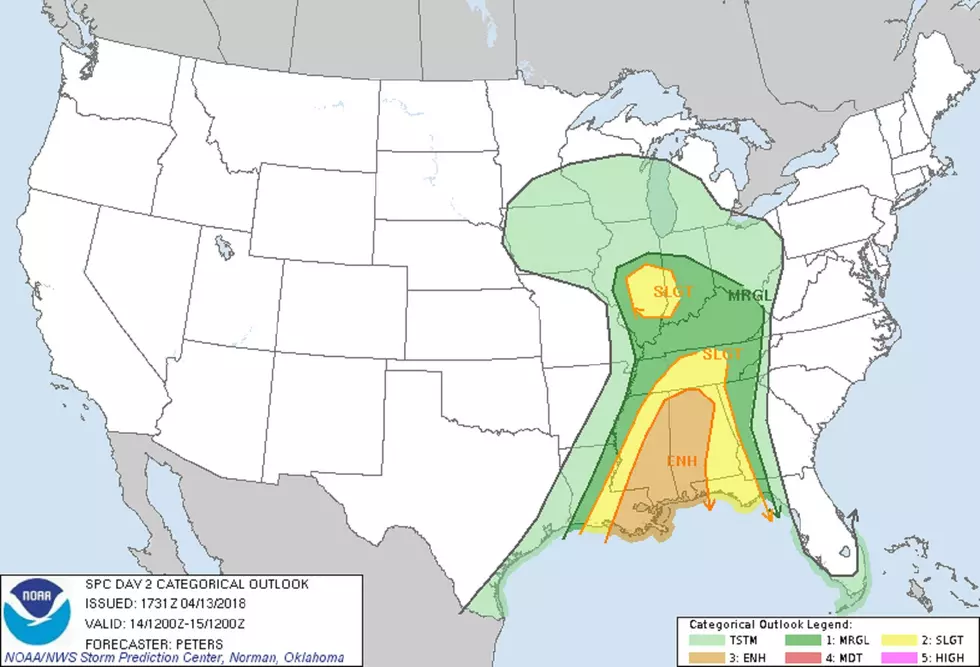
Tri-State Under a Marginal to Slight Risk for Severe Weather Saturday
Ah, spring. One minute it's 75 degrees, the next it's 48. Well, that IS a bit of an exaggeration. I can't imagine the kind of bad-disaster-movie event that would have to unfold for THAT to happen, but you get my meaning.
It's the Ohio Valley and, right now--on Friday afternoon, the time of this writing--it's a gusty 75 degrees.
Feels great.
But Eyewitness News, Your Weather Authority shows highs only in the low 50s on Sunday and Monday.
That's because a big ol' front will roll through beginning early Saturday and change things drastically.
It's why, at this moment in time, we have a marginal to slight risk for severe weather on Saturday.
Here's the official word from the National Weather Service's Storm Prediction Center:
...THERE IS AN ENHANCED RISK OF SEVERE THUNDERSTORMS ACROSS PORTIONS
OF THE CENTRAL GULF COAST STATES...
...THERE IS A SLIGHT RISK OF SEVERE THUNDERSTORMS SURROUNDING THE
ENHANCED RISK FROM THE NORTHERN GULF COAST TO TN...
...THERE IS A SLIGHT RISK OF SEVERE THUNDERSTORMS ACROSS PORTIONS OF
SOUTHERN IL AND IN...
...THERE IS A MARGINAL RISK OF SEVERE THUNDERSTORMS FROM THE LOWER
MISSISSIPPI VALLEY TO PART OF THE SOUTHEAST STATES AND NORTH TO THE
LOWER OH VALLEY...
...SUMMARY...
Strong to severe storms are expected across the lower Mississippi
Valley and central Gulf Coast States with a threat for damaging
winds and a few tornadoes, some possibly strong. Isolated severe
storms will be possible in the Midwest Saturday afternoon to early
evening.
...Synopsis...
A large trough deepening across the central U.S. today will shift
slowly eastward to the Mississippi Valley during Day 2. This trough
may begin to take on a negative tilt as progressive shortwave trough
moving through northern Mexico and central/south TX Saturday
afternoon tracks into the lower Mississippi Valley and northwest
Gulf by 12Z Sunday. The track of this latter trough and the
negative tilt will result in stronger height falls occurring
Saturday night across the lower and middle Mississippi Valley. At
the surface, the primary synoptic low is expected to track east from
northern MO into the lower Ohio Valley in vicinity of a warm front.
Meanwhile, a cold front, initially trailing through MO to western LA
at 12Z Saturday will advance east this forecast period and should
extend from western OH to the AL/GA border by the end of Day 2.
...Lower Mississippi Valley/Central Gulf Coast region to TN...
Showers and thunderstorms are expected to be ongoing at the start of
Day 2 from portion of the Ozarks and lower Ohio Valley through the
lower Mississippi Valley to TX Gulf Coast. In addition to the cold
front being a focus for strong to severe storms this forecast period
as it advances east, a potential outflow boundary extending from
west-central TN to northern MS and a couple of sub-synoptic lows
located along the cold front should also be monitored for areas of
increased low-level convergence. The eastward progression of the
southern extent of the central states trough and a westerly upper
level jet across the Gulf of Mexico will result in diffluent flow
pattern across the central Gulf Coat States severe risk areas.
Associated large-scale ascent will maintain convective development
across a moistening/destabilizing warm sector. MLCAPE across much
of the Slight and Enhanced risk areas should be up to 1500 J/kg with
2000 J/kg likely near the Gulf coast.
Front-parallel deep-layer shear vectors will favor a linear mode
with storms occurring along the cold front. However, the strength
of the deep-layer and low-level shear will also support sustained
rotating updrafts, with supercells possible east of the cold front
and embedded within a developing QLCS. Given the strength of the
southerly low-level jet (50-60 kt) and low-level shear, strong/
damaging winds (some significant) and a strong tornado or two will
be possible from southeast LA through eastern MS and western AL
Saturday afternoon into the evening.
...Lower Ohio Valley (IL/IN)...
Forcing for ascent within the exit region of a strong 500-mb jet
translating into the eastern periphery of the central states large
closed low will spread into the lower Ohio Valley by late Saturday
afternoon to the early evening. A surface low induced by this
feature will track east along a warm front which will extend through
central IL, IN, and OH. The strongest diurnal heating/steep
low-level lapse rate environment should be confined to portions of
IL/IN immediately ahead of the surface low. Low-topped
strong/severe convection should develop ahead of the cold front by
early afternoon across IL then spread into western IN by late
afternoon or early evening.
More From WBKR-FM


